


CAPTURE THE DATA.
MAKE IT CLEAR.
MAKE IT USEFUL.

Professional drone inspections, surveys and aerial data capture for residential and commercial projects.


Roof Inspections
From £79
Airmetrix provides high-resolution aerial roof inspections for residential and commercial properties, capturing areas that can be difficult, costly or disruptive to inspect from the ground.
Our drone surveys provide detailed visual evidence of the roof's condition, helping identify visible issues such as displaced or damaged tiles, gutter debris, vegetation growth, flashing concerns and other areas that may require further assessment.
Our advanced analysis software reviews captured imagery against thousands of benchmark observations, helping identify areas of concern and produce a clear, detailed report with supporting evidence and recommended next steps.
Whats Included:
✓ High-resolution aerial imagery
✓ Detailed coverage of key roof areas
✓ Clearly identified observations
✓ Location-specific photographic evidence
✓ Priority classifications
✓ Professional PDF inspection report
✓ Access to original imagery
Ideal for:
• Homeowners • Landlords • Property Managers • Surveyors
• Roofing Contractors • Commercial Properties

Building Surveys
Airmetrix provides detailed aerial surveys of residential, commercial and industrial buildings, capturing high-resolution imagery of areas that are difficult, costly or disruptive to inspect using traditional methods.
From façades and elevations to roofs, cladding and external structures, our aerial surveys provide clear visual evidence to support property assessments, maintenance planning and further professional investigation.
WHAT WE CAN CAPTURE
✓ Roofs & elevated structures
✓ Façades & external elevations
✓ Cladding & building envelopes
✓ Chimneys, flashing & roof details
✓ Gutters & drainage systems
✓ Hard-to-access areas
✓ High-resolution photographic evidence
CLEAR DATA.
PROFESSIONAL DELIVERY.

Captured imagery can be organised into a clear digital record, giving property owners, facilities teams and other professionals an efficient way to review building condition and identify areas requiring closer assessment.
From £179
Mapping & GIS


From £379
DATA BUILT AROUND YOUR PROJECT.
Airmetrix uses high-resolution aerial imagery to capture sites efficiently and transform them into accurate, detailed visual datasets.
From orthomosaic mapping and site measurements to 3D models and GIS-ready data, our aerial mapping services provide a clear view of land, property and development sites — supporting planning, measurement, progress monitoring and informed decision-making.
Depending on the project requirements, deliverables can include:
✓ High-resolution orthomosaic maps
✓ Aerial site plans & imagery
✓ Distance, area & volume measurements
✓ 3D models & point clouds
✓ Digital surface models
✓ Contour & elevation data
✓ GIS-compatible datasets
✓ Repeat surveys for change & progress analysis
Asset Inspections


From £179
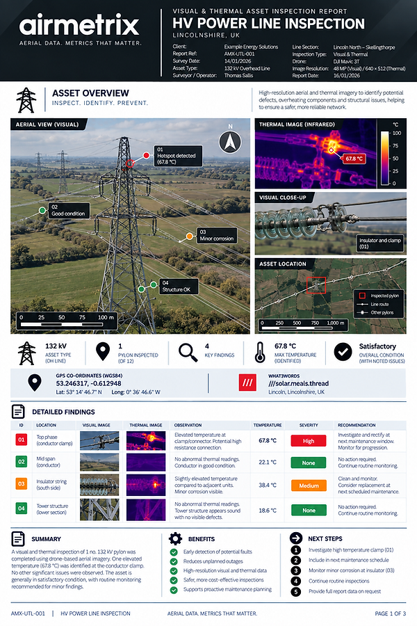
Airmetrix provides high-resolution aerial inspections of buildings, structures and infrastructure, capturing detailed visual evidence from areas that may be difficult, costly or disruptive to access using traditional methods.
From towers and structures to façades, plant, utilities and infrastructure, our drone inspections provide a clear visual record of asset condition — supporting maintenance planning, condition monitoring and further professional assessment.
DIFFICULT TO ACCESS.
EASY TO INSPECT.
Depending on the project requirements,
deliverables can include:
✓ High-resolution inspection imagery
✓ Close-up visual evidence
✓ Clearly referenced observations
✓ Thermal data
✓ Asset and component identification
✓ Repeatable condition monitoring
✓ Before-and-after comparisons
✓ Professional inspection reporting
CLEAR EVIDENCE. BETTER DECISIONS.

Solar Surveys

From £129
Airmetrix provides detailed aerial inspections of residential and commercial solar installations, capturing high-resolution imagery across individual panels and complete arrays.
Our surveys provide a clear visual record of the installation, helping identify visible damage, contamination, debris, shading concerns and other areas requiring closer assessment — without the need to access the roof directly.
SEE MORE.
INSPECT SAFER.
Depending on the project requirements,
deliverables can include:
✓ High-resolution aerial imagery
✓ Individual panel inspection
✓ Full-array overview imagery
✓ Visible damage identification
✓ Debris & contamination observations
✓ Indicative output calculations
✓ Clearly referenced photographic evidence
✓ Professional inspection reporting


FROM PANEL TO
COMPLETE ARRAY.
Whether it's a residential rooftop installation or a larger commercial solar array, aerial inspection provides an efficient way to document condition, identify visible concerns and create a detailed record for maintenance and further assessment.
THERMAL SOLAR
INSPECTIONS FROM £279

Upgrade your solar inspection with radiometric thermal imaging to identify temperature anomalies across individual panels and complete arrays that may not be visible in standard aerial imagery.
Construction Progress


From £189
Per visit
Airmetrix provides scheduled aerial progress monitoring for construction and development projects, creating a clear visual record of how your site evolves from groundworks through to completion.
Using consistent aerial viewpoints and high-resolution imagery, we make it easy to document progress, compare key stages and share project updates with clients, stakeholders and project teams.
ONE SITE.
EVERY STAGE.
Construction progress services can include:
✓ Scheduled site visits
✓ Consistent repeat photography
✓ High-resolution aerial imagery
✓ Overview & key-area photography
✓ Before-and-after comparisons
✓ Progress video & timelapse content
✓ Date-referenced digital archive
✓ Stakeholder-ready reporting
✓ Options to add on services